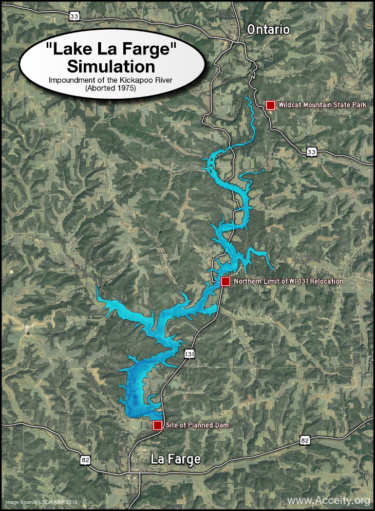
The Lake That Never Was
In 1962, the U.S. Congress authorized construction of a flood control dam on the Kickapoo River at La Farge, Wisconsin. The dam would protect La Farge and its downstream neighbors from the Kickapoo’s devastating flash floods. It would also create a 1,780 acre reservoir — “Lake La Farge” — that proponents hoped would draw tourists in search of fishing, boating, and lakefront recreation. Over a hundred farmers and landowners were made to sell their real estate to the federal government beginning in 1969 to make way for the planned reservoir. Construction crews set to work rebuilding Wisconsin Highway 131 around the anticipated lake. In 1971, the U.S. Army Corps of Engineers broke ground on an earthen dam at La Farge.
As work progressed, increased environmental scrutiny revealed problems. Studies showed that a dam would not only alter the local ecology and threaten endangered species in the Kickapoo Valley, but also take a severe toll on local water quality. The expense of maintaining the reservoir also raised concerns. In 1975, with the dam partially in place and half of the affected highway rebuilt, a failed cost-benefit analysis led the Corps of Engineers to halt the project. The cost had been $18 million, coupled with the destruction of the valley’s farming community — an unambiguous example of poor foresight and government waste.
Though Lake La Farge was never filled, the incomplete dam and an abrupt corner in Highway 131 remain as visible reminders of the failed project. Likewise, the property acquired for the reservior remains largely vacant, though it at last found use in 2000 when it was transferred from the Corps of Engineers to the Ho-Chunk Nation and the State of Wisconsin for the creation of the Kickapoo Valley Reserve. The lake that never was thus remains fixed on the mental map of many Kickapoo Valley residents.
I created the map above to define the extent of the planned lake more clearly. The map is based on elevation data I had downloaded from the USGS NED for my Driftless Area Map, and it simulates the area that would have been flooded if Lake La Farge had been filled to the proposed elevation of 840 feet above sea level. The base layer of the map is a mosaic of 2010 aerial imagery from the USDA National Agricultural Imagery Program. The map does not account for sediment deposition and other landscape changes that the dam could have wrought, but it offers a general picture of how “Lake La Farge” might have fit into the modern landscape.
Learn More
Brad’s History – From Brad Steinmetz, author of That Dam History: The Story of the La Farge Dam Project.
The Kickapoo Valley Reserve – the valley today, with several pages of history
